Our hiking trip to Smrekovec!
The route is easy and signposted, it can be a touring ski route as we will describe it, or it can be adapted to a snowshoe ascent and a skiboard descent. It can also be a normal winter hike with the right equipment.
INFORMATION
| Time: 4 h | Altitude difference: 800 m | Lowest point: 1310 mnv |
| Length: 12.5 km | Average speed: 3 km/h | Highest point: 1580 mnv |
POT
From Camping Menin we drove towards Mozirje, where we took the second exit at the first roundabout and the third exit towards Žekovec at the second roundabout. After a 2.2 km ride at a major crossroads near the Vid Inn, we turned right towards Golte and continued straight on to Šmihel nad Mozirjem. 1 km above the village of Šmihel, at a crossroads, turn left, then after 300 m turn left again, as directed by the sign for Golte. We continued straight along the asphalt road to the top and arrived at the Alpine Garden at Golte.
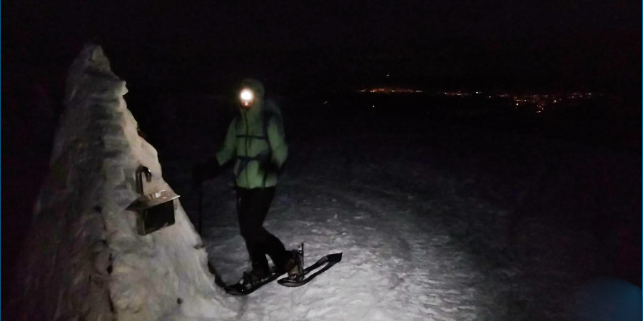
THE RISE TO THE TOP
From the Alpine Garden, where we parked, we first headed right and down towards the Mozirski hut, and just before it we took the path up to the left. The signpost there directed us to the left, on the road to Smrekovec. We continued along the wider train and soon reached a clearing. We kept slightly to the right until we reached another clearing, when we continued straight to a ridge with a signpost pointing the way towards Smrekovec. There was a longer descent from the ridge, so at this point, as touring skiers, we took off our skins and skied down to the road with the signpost, which pointed us straight ahead again. We put our skis back on and followed the tree markings through the spruce forest for the next few kilometres. The terrain became very undulating and we had to ski down quite a few times with skins on, where extra caution is very important. After a last short descent we reached the road leading to the hut on Smrekovec. At the cottage, the signpost initially directed us left upwards, but when we reached the wire fence with a gate, we continued right, up the steep bank to the top of Smrekovec.
SPUST
We all happily skied down the ascent route, or we could have skied straight down to the hut on Smrekovec if we already knew the terrain. From the hut we skied down the road as far as it would go, then put the skins back on and continued back over the undulating terrain. After a last steep climb, we reached the ridge, from where we skied slightly to the right the whole way and followed the last forest road back to the Alpine Garden.
IMPORTANT INFORMATION FOR PLANNING ALPINE SKIING IN THE HIGH MOUNTAINS
– It is advisable to get a local guide, especially if you are travelling in the area. a must if you are new to winter conditions and touring skiing.
– Mountaineering skills (attitude, equipment, respect for nature) and knowledge of the terrain in the high mountains is especially important in winter!
– Monitoring mountain conditions: weather, visibility, avalanche levels: http://www.meteo.si/met/sl/weather/bulletin/mountain/avalanche/
– Technique for skiing on unprocessed snow.
– Information on the cross-section of the snow cover.
– Monitor the weather and prepare accordingly; winter temperatures are variable in the high mountains.
Our tour can be accessed at: Komoot – GPS LINK – Download the Komoot app on your mobile phone to link to the route. To activate the route, select “Start Navigation” and the app will give you two options; 1) GPS from where you are and it will take you to the starting point of the climb, 2) or start by navigating the climb itself.
We are always at your disposal for any questions you may have.
Day or night, summer or winter, caution is never a waste of time in the high mountains! We wish you a safe step!
Sunny greetings, Funpark Menina team!